


AviNavi, navigation for pilots

AviNavi, navigation for pilots का विवरण
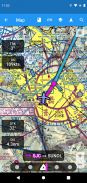
विमानन नेविगेशन को सरल और किफायती बनाया गया है। सभी वीएफआर, कम ऊंचाई वाले आईएफआर और महाद्वीपीय संयुक्त राज्य के लिए उपकरण दृष्टिकोण चार्ट, पूर्ण उड़ान योजना के साथ, वायुमार्ग नेविगेशन के लिए समर्थन सहित। Nexrad, METARs और AIRMETS/SIGMETS के लिए ओवरले उड़ान सुरक्षा में सुधार करते हैं, और विस्तृत हवाई अड्डे की जानकारी (रनवे, आवृत्तियों, ईंधन, मौसम) आपकी उंगलियों पर है।
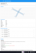
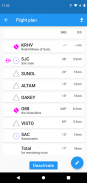
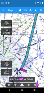
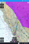
हवाई अड्डे, वीओआर, एनडीबी या चौराहे को खोजने या चुनने के लिए मूविंग मैप का उपयोग करें और सीधे नेविगेशन शुरू करें, या उड़ान योजना में जोड़ें। वैकल्पिक रूप से उड़ान योजना को टेक्स्ट में दर्ज करें, उदा। KPAO SUNOL V334 SAC KSAC सभी एयरवे नेविगेशन बिंदुओं सहित पूर्ण उड़ान योजना को लोड करेगा।
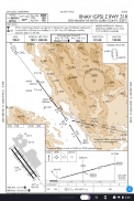
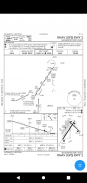
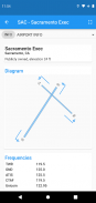
इंस्ट्रूमेंट एप्रोच चार्ट में एयरपोर्ट डायग्राम, STARS, DP और मिनिमम के साथ-साथ लीजेंड भी शामिल हैं।
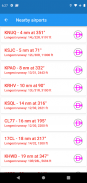
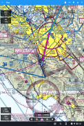
आस-पास के हवाई अड्डों को हरे या लाल रंग में दिखाया गया है ताकि यह इंगित किया जा सके कि उन हवाई अड्डों पर हवा के बिना ग्लाइड होने की संभावना है या नहीं।
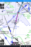
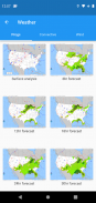
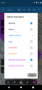
METAR, TAF, AIRMET, SIGMET, ठेला चार्ट, संवहनी आउटलुक और पवन चित्रमय और/या पाठ्य जानकारी के रूप में उपलब्ध हैं। METARs और AIRMETS/SIGMETS को लेयर्स बटन का उपयोग करके मैप पर ओवरले किया जा सकता है। हवाई अड्डे की जानकारी METARs और TAF को सादे अंग्रेजी में दिखाती है, और अलग-अलग समय और ऊंचाई के लिए प्रोग चार्ट, संवहनी आउटलुक और पवन ग्राफिक्स पूर्ण स्क्रीन ग्राफिक्स के रूप में उपलब्ध हैं।
नि: शुल्क परीक्षण अवधि के बाद, अविनावी को मासिक या वार्षिक सदस्यता की आवश्यकता होती है।
AviNavi, navigation for pilots - Version 4.5.7
(08-01-2024)
AviNavi, navigation for pilots - एपीके जानकारी
एपीके संस्करण: 4.5.7पैकेज: com.bbflight.avinaviLatest Version of AviNavi, navigation for pilots
अन्य संस्करण


 3.64
3.64


Apps in the same category


